PRODUCT DETAILS
Features
-
High-speed laser ranging sampling capability of 32,000 times per second
-
Non-contact energy and signal transmission technology
-
Reliable and stable operation for a long time
-
Coverage area with a radius of 30 meters on a two-dimensional plane
-
360° omnidirectional laser ranging scanning
-
Excellent application in both indoor and outdoor environments
-
Built-in speed detection and adaptive system
-
Cost reduction because there is no need to provide a complex power supply system
-
The emitted laser power complies with IEC-60825 Class 1 human eye safety level
Description
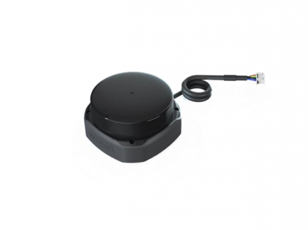
RPLIDAR S2 is a new generation of low-cost two-dimensional laser ranging radar (LIDAR), which can perform a 360-degree omni-directional laser ranging scan within a 30-meter radius of a two-dimensional plane, and generate a flat point cloud map of the space in which it is located information. These cloud map information can be used in practical applications such as map surveying and mapping, robot positioning and navigation, and object/environment modeling.
RPLIDAR S2 adopts laser time-of-flight ranging technology, coupled with the high-speed laser acquisition and processing mechanism developed by SLAMTEC, which can perform 32,000 ranging actions per second. It uses non-contact energy and signal transmission technology, overcomes the life limitation of traditional lidar, and can operate reliably and stably for a long time.
Compared with other series of lidars, RPLIDAR S2 has more stable ranging performance when detecting long-distance objects, switching between black and white objects, and strong light directing objects. It can achieve ideal mapping within a 30-meter ranging radius in indoor and outdoor environments. As a result, the scope of application can be expanded to more consumer-level commercial scenarios.
For your convenience, we made a table comparing different RPLiDARs so you can easily pick one that suits your project!
| Item | Measurement Performance | ||||
|---|---|---|---|---|---|
| Distance Range | Measurement Resolution | Angular Resolution | Sample Rate | Working Environment | |
| RPLIDAR A1M8-R6 | 0.15m -12m | <0.5 mm | ≤1° | 2000-8000 Hz | Indoor |
| <1% of actual distance * | |||||
| RPLIDAR A2M6 | 0.2m – 18m | <0.5 mm | ≤0.9° | 2000-8000 Hz | Indoor |
| <1% of actual distance * | |||||
| RPLIDAR A2M8 | 0.15m -12m | <0.5 mm | ≤0.9° | 2000-8000 Hz | Indoor |
| <1% of actual distance * | |||||
| RPLIDAR A3M1 | White objects: 25 m | 0.225° | 16 kHz or 10 kHz | Indoor & Outdoor | |
| Black objects: 10 m | |||||
| RPLIDAR S1 | White Objects: 40m | 3cm | 0.313°-0.587° | 9200 Hz | Indoor& Outdoor |
| Black Objects: 10m | |||||
| RPLIDAR S2 | White Objects: 30m | 5cm | 0.12° | 32 kHz | Indoor& Outdoor |
| Black Objects: 10m | |||||
| SLAMTEC MAPPER M1M1 | 20m | 5cm | 7000 Hz | Indoor & Outdoor | |
| SLAMTEC MAPPER M2M1 Pro | 40m | 5cm | 9200Hz | Indoor & Outdoor | |
Application
-
Universal simultaneous positioning and mapping (SLAM)
-
Environmental scanning and 3D reconstruction
-
Service robots and industrial fields that need to work continuously for a long time
-
Navigation and positioning of home care/cleaning robots
-
General robot navigation and positioning
-
Positioning and obstacle detection of smart toys
Specification
|
Parameters |
Details |
|
Measuring distance |
White object:30m |
|
Black object:10m |
|
|
Sampling frequency |
32kHz |
|
Scanning frequency |
10Hz |
|
Angle resolution |
0.12° |
|
Communication interface |
TTL UART |
|
Communication rate |
1M |
|
Measurement accuracy |
±5cm |
|
Supply voltage |
5V |
|
Supply voltage ripple |
20-50mV |
|
System startup current |
1500mA |
|
Supply current |
40mA(5V power supply, during sleep) |
|
400mA(5V power supply, working) |
|
|
Communication interface input and output voltage |
3.3V |
|
Range of working temperature |
-10℃ to 50℃ |
|
Weight |
190g |
Mechanical dimension drawing
Part List
|
RPLIDAR S2 module (built-in PWM motor driver) |
1 |
|
USB adapter |
1 |
|
Micro-USB cable |
1 |
|
Power cable |
1 |
ECCN/HTS
| HSCODE | 9031499090 |
| UPC |
RPLiDAR S2 Low Cost 360 Degree Laser Range Scanner – 30M Range
$483.00
RPLIDAR S2 is a new generation of low-cost two-dimensional laser ranging radar, which can perform a 360-degree omni-directional laser ranging scan within a 30-meter radius of a two-dimensional plane, and generate a flat point cloud map of the space in which it is located information. It can be used in practical applications such as map surveying and positioning and navigation.
PRODUCT DETAILS
Features
-
High-speed laser ranging sampling capability of 32,000 times per second
-
Non-contact energy and signal transmission technology
-
Reliable and stable operation for a long time
-
Coverage area with a radius of 30 meters on a two-dimensional plane
-
360° omnidirectional laser ranging scanning
-
Excellent application in both indoor and outdoor environments
-
Built-in speed detection and adaptive system
-
Cost reduction because there is no need to provide a complex power supply system
-
The emitted laser power complies with IEC-60825 Class 1 human eye safety level
Description
RPLIDAR S2 is a new generation of low-cost two-dimensional laser ranging radar (LIDAR), which can perform a 360-degree omni-directional laser ranging scan within a 30-meter radius of a two-dimensional plane, and generate a flat point cloud map of the space in which it is located information. These cloud map information can be used in practical applications such as map surveying and mapping, robot positioning and navigation, and object/environment modeling.
RPLIDAR S2 adopts laser time-of-flight ranging technology, coupled with the high-speed laser acquisition and processing mechanism developed by SLAMTEC, which can perform 32,000 ranging actions per second. It uses non-contact energy and signal transmission technology, overcomes the life limitation of traditional lidar, and can operate reliably and stably for a long time.
Compared with other series of lidars, RPLIDAR S2 has more stable ranging performance when detecting long-distance objects, switching between black and white objects, and strong light directing objects. It can achieve ideal mapping within a 30-meter ranging radius in indoor and outdoor environments. As a result, the scope of application can be expanded to more consumer-level commercial scenarios.
For your convenience, we made a table comparing different RPLiDARs so you can easily pick one that suits your project!
| Item | Measurement Performance | ||||
|---|---|---|---|---|---|
| Distance Range | Measurement Resolution | Angular Resolution | Sample Rate | Working Environment | |
| RPLIDAR A1M8-R6 | 0.15m -12m | <0.5 mm | ≤1° | 2000-8000 Hz | Indoor |
| <1% of actual distance * | |||||
| RPLIDAR A2M6 | 0.2m – 18m | <0.5 mm | ≤0.9° | 2000-8000 Hz | Indoor |
| <1% of actual distance * | |||||
| RPLIDAR A2M8 | 0.15m -12m | <0.5 mm | ≤0.9° | 2000-8000 Hz | Indoor |
| <1% of actual distance * | |||||
| RPLIDAR A3M1 | White objects: 25 m | 0.225° | 16 kHz or 10 kHz | Indoor & Outdoor | |
| Black objects: 10 m | |||||
| RPLIDAR S1 | White Objects: 40m | 3cm | 0.313°-0.587° | 9200 Hz | Indoor& Outdoor |
| Black Objects: 10m | |||||
| RPLIDAR S2 | White Objects: 30m | 5cm | 0.12° | 32 kHz | Indoor& Outdoor |
| Black Objects: 10m | |||||
| SLAMTEC MAPPER M1M1 | 20m | 5cm | 7000 Hz | Indoor & Outdoor | |
| SLAMTEC MAPPER M2M1 Pro | 40m | 5cm | 9200Hz | Indoor & Outdoor | |
Application
-
Universal simultaneous positioning and mapping (SLAM)
-
Environmental scanning and 3D reconstruction
-
Service robots and industrial fields that need to work continuously for a long time
-
Navigation and positioning of home care/cleaning robots
-
General robot navigation and positioning
-
Positioning and obstacle detection of smart toys
Specification
|
Parameters |
Details |
|
Measuring distance |
White object:30m |
|
Black object:10m |
|
|
Sampling frequency |
32kHz |
|
Scanning frequency |
10Hz |
|
Angle resolution |
0.12° |
|
Communication interface |
TTL UART |
|
Communication rate |
1M |
|
Measurement accuracy |
±5cm |
|
Supply voltage |
5V |
|
Supply voltage ripple |
20-50mV |
|
System startup current |
1500mA |
|
Supply current |
40mA(5V power supply, during sleep) |
|
400mA(5V power supply, working) |
|
|
Communication interface input and output voltage |
3.3V |
|
Range of working temperature |
-10℃ to 50℃ |
|
Weight |
190g |
Mechanical dimension drawing
Part List
|
RPLIDAR S2 module (built-in PWM motor driver) |
1 |
|
USB adapter |
1 |
|
Micro-USB cable |
1 |
|
Power cable |
1 |
ECCN/HTS
| HSCODE | 9031499090 |
| UPC |


