PRODUCT DETAILS
Features
- Measures distance data in more than 8000 times/s
- 360 Degree Omnidirectional Laser Range Scanning
- 8000 times sample rate, the highest in the current economical LIDAR industry
- OPTMAG Original Design, prolong the life-span
- Configurable Scan Rate from 2-10Hz
- Ideal for Robot Navigation and Localization
- Plug and Play
Description
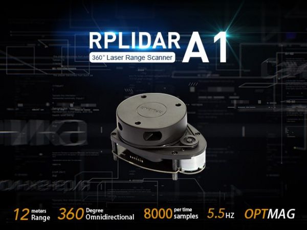
RPLIDAR A1 is a low cost 360-degree 2D laser scanner (LIDAR) solution developed by SLAMTEC. The system can perform a 360degree scan within a 6meter range. The produced 2D point cloud data can be used in mapping, localization, and object/environment modeling.
RPLIDAR A1’s scanning frequency reached 5.5 Hz when sampling 360 points each round. And it can be configured up to 10 Hz maximum.
RPLIDAR A1 is basically a laser triangulation measurement system. It can work excellently in all kinds of indoor environments and outdoor environments without sunlight.
For your convenience, we made a table comparing different RPLiDARs so you can easily pick one that suits your project!
| Item | Measurement Performance | ||||
|---|---|---|---|---|---|
| Distance Range | Measurement Resolution | Angular Resolution | Sample Rate | Working Environment | |
| RPLIDAR A1M8-R6 | 0.15m -12m | <0.5 mm | ≤1° | 2000-8000 Hz | Indoor |
| <1% of actual distance * | |||||
| RPLIDAR A2M6 | 0.2m – 18m | <0.5 mm | ≤0.9° | 2000-8000 Hz | Indoor |
| <1% of actual distance * | |||||
| RPLIDAR A2M8 | 0.15m -12m | <0.5 mm | ≤0.9° | 2000-8000 Hz | Indoor |
| <1% of actual distance * | |||||
| RPLIDAR A3M1 | White objects: 25 m | 0.225° | 16 kHz or 10 kHz | Indoor & Outdoor | |
| Black objects: 10 m | |||||
| RPLIDAR S1 | White Objects: 40m | 3cm | 0.313°-0.587° | 9200 Hz | Indoor& Outdoor |
| Black Objects: 10m | |||||
| RPLIDAR S2 | White Objects: 30m | 5cm | 0.12° | 32 kHz | Indoor& Outdoor |
| Black Objects: 10m | |||||
| SLAMTEC MAPPER M1M1 | 20m | 5cm | 7000 Hz | Indoor & Outdoor | |
| SLAMTEC MAPPER M2M1 Pro | 40m | 5cm | 9200Hz | Indoor & Outdoor | |
Application Scenarios
- Home service /cleaning robot navigation and localization
- General robot navigation and localization
- Smart toy’s localization and obstacle avoidance
- Environment scanning and 3D re-modeling
- General simultaneous localization and mapping (SLAM)
Specifications
| Specification | Details |
| Dimensions | 98.5mm x70mm x60mm |
| Weight | G.W 170g |
| Battery | Exclude |
| Distance Range | 0.15 – 6m,White objects |
| Angular Range | 0-360 Degree |
| Distance Resolution | <0.5mm |
| Angular Resolution | ≤1Degree |
| Sample Duration | 0.5ms |
| Sample Frequency | 2000~2010Hz |
| Scan Rate | 1~10Hz,Typical 5.5Hz, |
Part List
- 1 x RPLIDAR A1(PWM motor driver embedded
- 1 x USB Adapter
- 1 x RPLIDAR A1 communication cable
ECCN/HTS
| HSCODE | 9031499090 |
| UPC |
RPLiDAR A1M8-R6 360 Degree Laser Scanner Kit – 12M Range
$136.00
RPLIDAR A1 is a low cost 360-degree 2D laser scanner (LIDAR) solution developed by SLAMTEC. The system can perform a 360degree scan within a 6meter range. The produced 2D point cloud data can be used in mapping, localization, and object/environment modeling.
PRODUCT DETAILS
Features
- Measures distance data in more than 8000 times/s
- 360 Degree Omnidirectional Laser Range Scanning
- 8000 times sample rate, the highest in the current economical LIDAR industry
- OPTMAG Original Design, prolong the life-span
- Configurable Scan Rate from 2-10Hz
- Ideal for Robot Navigation and Localization
- Plug and Play
Description
RPLIDAR A1 is a low cost 360-degree 2D laser scanner (LIDAR) solution developed by SLAMTEC. The system can perform a 360degree scan within a 6meter range. The produced 2D point cloud data can be used in mapping, localization, and object/environment modeling.
RPLIDAR A1’s scanning frequency reached 5.5 Hz when sampling 360 points each round. And it can be configured up to 10 Hz maximum.
RPLIDAR A1 is basically a laser triangulation measurement system. It can work excellently in all kinds of indoor environments and outdoor environments without sunlight.
For your convenience, we made a table comparing different RPLiDARs so you can easily pick one that suits your project!
| Item | Measurement Performance | ||||
|---|---|---|---|---|---|
| Distance Range | Measurement Resolution | Angular Resolution | Sample Rate | Working Environment | |
| RPLIDAR A1M8-R6 | 0.15m -12m | <0.5 mm | ≤1° | 2000-8000 Hz | Indoor |
| <1% of actual distance * | |||||
| RPLIDAR A2M6 | 0.2m – 18m | <0.5 mm | ≤0.9° | 2000-8000 Hz | Indoor |
| <1% of actual distance * | |||||
| RPLIDAR A2M8 | 0.15m -12m | <0.5 mm | ≤0.9° | 2000-8000 Hz | Indoor |
| <1% of actual distance * | |||||
| RPLIDAR A3M1 | White objects: 25 m | 0.225° | 16 kHz or 10 kHz | Indoor & Outdoor | |
| Black objects: 10 m | |||||
| RPLIDAR S1 | White Objects: 40m | 3cm | 0.313°-0.587° | 9200 Hz | Indoor& Outdoor |
| Black Objects: 10m | |||||
| RPLIDAR S2 | White Objects: 30m | 5cm | 0.12° | 32 kHz | Indoor& Outdoor |
| Black Objects: 10m | |||||
| SLAMTEC MAPPER M1M1 | 20m | 5cm | 7000 Hz | Indoor & Outdoor | |
| SLAMTEC MAPPER M2M1 Pro | 40m | 5cm | 9200Hz | Indoor & Outdoor | |
Application Scenarios
- Home service /cleaning robot navigation and localization
- General robot navigation and localization
- Smart toy’s localization and obstacle avoidance
- Environment scanning and 3D re-modeling
- General simultaneous localization and mapping (SLAM)
Specifications
| Specification | Details |
| Dimensions | 98.5mm x70mm x60mm |
| Weight | G.W 170g |
| Battery | Exclude |
| Distance Range | 0.15 – 6m,White objects |
| Angular Range | 0-360 Degree |
| Distance Resolution | <0.5mm |
| Angular Resolution | ≤1Degree |
| Sample Duration | 0.5ms |
| Sample Frequency | 2000~2010Hz |
| Scan Rate | 1~10Hz,Typical 5.5Hz, |
Part List
- 1 x RPLIDAR A1(PWM motor driver embedded
- 1 x USB Adapter
- 1 x RPLIDAR A1 communication cable
ECCN/HTS
| HSCODE | 9031499090 |
| UPC |


